
Welcome to South Sulawesi
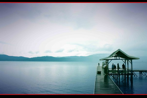
Matano lake , also known as Matana is a natural lake in South Sulawesi. It is the deepest lake in Indonesia (ranked by maximum depth), and the 8th deepest lake in the world. It is surrounded by ring of small mountain rock.
The only lake in Indonesia having a cryptodepression (the bottom of the lake is below sea level) is Lake Matano. The lakes and reservoirs supply water for personal and commercial. The waters of Lake Matano are exceptionally clear, visibility is good, and home to many species of endemic fish are highly dependent on visual cues and Crowe, Sean, Biogeochemical cycling in iron-rich Lake Matano.and other animals as well as many plants.
![]()

Bantimurung Waterfall in Maros regency, South Sulawesi is one of tourism destinations that you should not miss. Bantimurung Waterfall can be reached with one-hour drive from Makassar and 30-minute drive from Hasanuddin Airport, Makassar. Bantimurung waterfall is situated at the valley of a limestone hill with its fertile tropical vegetation. Bantimurung waterfall is a government protected natural reserve that not just houses a beautiful waterfall and 1000 ha of surrounding forest.
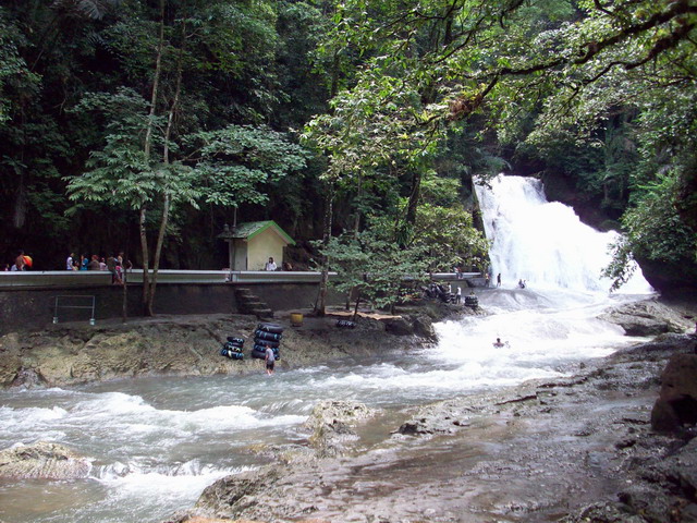
The characteristic of Bantimurung Waterfall is hills panorama and natural waterfall cascading from the top of cliffs. There are also several caves in around the waterfall which make this area an ideal habitat for many types of butterflies and rare bird that make Bantimurung also a rare butterfly's reservation. The naturalist Alfred Wallace collected specimens here in the mid 1800's. Among the butterflies that he caught was the Papilo Androcles, one of the rarest and biggest, with a tail like a swallow. The best time to see living butterflies is when the sun appears after a rain shower. They form a riot of color as they fly from one shrub to another.
Nowadays, entomologists still come here to look at the butterflies and other insects. Bantimurung Waterfall is a beautiful Natural Reserve with white falls and lots of beautiful butterflies make it worth a visit.
![]()
The distance that must be taken is 30 km or 1 hour from Makassar to Maros. While the distance from the Maros to the location of the site is 13 km or about 45 minutes because of lack of good roads impassable. So the total distance itself is 43 km and travel time that must be taken is 2 hours.


Vehicle Access
To reach this location can be reached by car or motorcycle.Whereas if you want to use the pete-pete (mini bus), the route to be taken are:
Pete-pete 05 - get off at Pioneer Road Independence - disconnected pete-pete Power majors - get off at Terminal Power - rose pete-pete majors Maros - get off at the terminal Maros - rose pete-pete Bantimurung goal - down the hall toward the Leang-Leang - arrived at Leang-Leang. It could also just take the pete-pete Bantimurung majors and down the hallway toward the Prehistoric Park Leang-Leang. Or by chartered car to go Parks Leang-Leang.
Pete-pete 05 - get off at Pioneer Road Independence - disconnected pete-pete Power majors - get off at Terminal Power - rose pete-pete majors Maros - get off at the terminal Maros - rose pete-pete Bantimurung goal - down the hall toward the Leang-Leang - arrived at Leang-Leang. It could also just take the pete-pete Bantimurung majors and down the hallway toward the Prehistoric Park Leang-Leang. Or by chartered car to go Parks Leang-Leang.
Visitor Ticket Prices
- Tourism: Rp. 10.000/orang
- Local Tourist: Rp. 3.000/orang
- Child school / group: Rp.2.000/orang
Total Cost
- With a couple of times to change the pete-pete: Rp. 22.500/orang
- By chartering or car-pete pete: Rp. 75,000.
Services and Facilities
Wisma post ticket sales, along the track, 4 pieces gazebo, bridge liaison.
Leang-leang are part of hundreds of prehistoric caves scattered on rocky hills (karst) Maros-Pangkep. Leang means cave in Makassar language (Indonesian: liang which means the hole).Leang-Leang Prehistory Park is located in District Batimurung, Maros, South Sulawesi.
Leang-leang are part of hundreds of prehistoric caves scattered on rocky hills (karst) Maros-Pangkep. Leang means cave in Makassar language (Indonesian: liang which means the hole).Leang-Leang Prehistory Park is located in District Batimurung, Maros, South Sulawesi.
Wall paintings in caves at Leang-Leang looks quite interesting.From these pictures, we can know what kind of prehistoric human life. One of the images is estimated as a stamp palms palms belonging to one tribe member who has followed the ritual of cutting a finger. The ritual was conducted as a sign of mourning for the death of those closest. The pictures on the second lot of the red cave, which is made from a natural dye that can penetrate into the solid rock pores that can not be erased and survived thousands of years.
Inventors Leang-leang Goa is Mister and Miss Heeren Van Heekeren Palm. Two Dutch archaeologists have found the pictures on the walls of the cave (rock painting) in Goa, and Petta Pettae Kere in 1950. Age of ancient paintings on the Leang-Leang estimated 5,000 years. Some archaeologists even believe that some of the cave has been inhabited since 8,000 to 3000 BC (BCE).
In Goa and Goa Petta Kere Pettae have pictures on the walls of hand-leang Leang.
Goa Pettae facing west. Images found in this cave is five and one hand drawing a picture hog deer jumped by an arrow in his chest.In addition, both archaeological artifacts were also found flakes, blades, and the shells are deposited at the mouth of the cave. To see this, we have to climb 26 stairs.
Goa Petta Kere located 300 meters next to the Cave Pettae.Artefacts found in this cave are 2 images hog deer, 27 images of your hand, flakes tool bar, and arrowheads. To reach this cave visitors must climb 64 stairs. Prehistoric Park Landscape Leang-Leang looks really beautiful, so perfect for nature tourism cultural tourism as well.
Location: Village Leang-Leang Bantimurung, Maros Regent, South Sulawesi.
Area: about 1.5 acres
Distance and Time Travel
![]()

The long drive from the lowlands to the mountain stronghold of Tanaopens up a breath-taking new world. The rugged mountains and verdant valleys are home to a people whose love of religious spectacle is equaled only by their hospitality. With majestic panoramas, captivating villages and dramatic ceremonies, Tana Toraja is the undisputed highlight of any journey to Sulawesi.
Upgraded roads, an airport and several star-rated hotels have opened the Toraja highland to visitors of all interests. The essence of the Toraja beliefs and way of life can be experienced without undue effort, as many interesting sites are clustered around the town of Rantepao, easily accessible by road.

Toraja Land whose ancestor oriented group believes that their forefathers descended from heaven onto a mountain some twenty generations ago. Their colourful culture is especially rich in elaborate sacrificial, post mortuary, and cave burial sites.
Tana Toraja (Toraja Land), which lies in the north of the province is known for its unique culture and ancient traditions. The center of tourism is Rantepao, 328 km from Ujung Pandang by road. There are several small bungalow hotels at Rantepao, and Makale, the district capital. The entry to Tana Toraja is marked by a gate built in traditional boat-shaped architecture. The road passes through the mountains of Kandora and Gandang on which, according to Toraja mythology, the first ancestors of celestial beings descended from heaven. The majority of the people still follows an ancestral cult called "Aluk Todolo" which governs all traditional ceremonies. From Rantepao, side trips can be made to Kete, a traditional village where there are handicraft and unique shops. Behind the village there is a grave site on a hillside. Life-size statues guard over old coffins. As roads are not always paved, it is necessary to use a jeep or walk if the weather is good (between May and October).

Two cliff graves easy to reach are Lemo and Londa. Londa is one of the oldest hanging graves belonging to the nobility. A large balcony is filled with effigies of the dead. Kerosene lamps with young village guides, can be hired to enter the caves to see skeletons and old coffins. At Lemo, burial chambers are cut out of the rock and several balconies filled with effigies look out while new caves are being dug to serve as family graves.
There are several grave sites and traditional villages of which Palawa is a classic example of a village on a small hill with "Tongkonan" or a burial place with celebrations and festivals. Visitors are welcome but they are expected to adhere to local customs of dress, seating and bringing a token present.
![]()

Samalona is a small island in the Straits of Makassar, precisely on the southwest coast of South Sulawesi . Administratively, this island including the city of Makassar, South Sulawesi. Position more precisely located on the west district Wajo, Makassar, a distance of approximately 2 km and can be seen clearly from these districts. To reach this island could use fishing boats (boats with outboard engines) and required travel time not more than 0.5 hours. On this island stands a lighthouse that is used as a sign of land boundary for big ships.
Samalona is an archipelago that could be seen clearly from the Citadel Fort Rotterdam in the area Keling - Makassar. Mandalika is only 500 meters from the edge of the cliff fortress Fort Rotterdam. Samalona Island is a cluster of circular coral island with an area of 2.34 hectares. This small island is one nautical tourist destination visited by many local and foreign tourists. White sand and crystal clear water make this island perfect for sunbathing. In addition, this island is very good area for diving (diving), because there are around coral reefs inhabited by diverse marine tropical fish, colorful, and other marine biota.
The best time to tour the island Samalona is from February to October.

The island is saving a million mystery about his wreck of the ship-relics of World War II. There are about seven boats that sank in the area of this island, among them: Maru ship, owned by a Japanese warship sank at a depth of about 30 meters; ship Lancaster Bomber which also sank at a depth of about 30 meters; submarine hunter (gunboat) Japanese-owned ; Hakko Maru cargo ship made in the Netherlands, and Japan's submarines. Wrecked ships have been transformed into a reef and became a "house" or "residence" for hundreds of diverse marine life forms, and type and color that is very admirable. The beauty of this is the major attraction for tourists to come swim in the carcasses of the shipwreck.
In addition to the mystery and beauty of the marine park, tourists can also watch the sunrise (sunrise) and sunset (sunset) at a similar position. In this island, tourists can also enjoy the delights of a variety of fresh seafood cooked in a way that is quite unique, that is placed on top of coconut shell and then covered with deciduous trees that grow around the island. In this way, the smell of charcoal smoke wafted immediately and could arouse appetite.
At this location is a simple lodging house-shaped stage that can accommodate about 20 people. In addition, several small dining is also available that provides a variety of fresh seafood. Samalona Island is about 6.8 km from the city of Makassar, and can be reached in about 20-30 minutes by speed boat with a capacity of maximum 12 people.
Samalona is an archipelago that could be seen clearly from the Citadel Fort Rotterdam in the area Keling - Makassar. Mandalika is only 500 meters from the edge of the cliff fortress Fort Rotterdam. Samalona Island is a cluster of circular coral island with an area of 2.34 hectares. This small island is one nautical tourist destination visited by many local and foreign tourists. White sand and crystal clear water make this island perfect for sunbathing. In addition, this island is very good area for diving (diving), because there are around coral reefs inhabited by diverse marine tropical fish, colorful, and other marine biota.
The best time to tour the island Samalona is from February to October.
The island is saving a million mystery about his wreck of the ship-relics of World War II. There are about seven boats that sank in the area of this island, among them: Maru ship, owned by a Japanese warship sank at a depth of about 30 meters; ship Lancaster Bomber which also sank at a depth of about 30 meters; submarine hunter (gunboat) Japanese-owned ; Hakko Maru cargo ship made in the Netherlands, and Japan's submarines. Wrecked ships have been transformed into a reef and became a "house" or "residence" for hundreds of diverse marine life forms, and type and color that is very admirable. The beauty of this is the major attraction for tourists to come swim in the carcasses of the shipwreck.
In addition to the mystery and beauty of the marine park, tourists can also watch the sunrise (sunrise) and sunset (sunset) at a similar position. In this island, tourists can also enjoy the delights of a variety of fresh seafood cooked in a way that is quite unique, that is placed on top of coconut shell and then covered with deciduous trees that grow around the island. In this way, the smell of charcoal smoke wafted immediately and could arouse appetite.
At this location is a simple lodging house-shaped stage that can accommodate about 20 people. In addition, several small dining is also available that provides a variety of fresh seafood. Samalona Island is about 6.8 km from the city of Makassar, and can be reached in about 20-30 minutes by speed boat with a capacity of maximum 12 people.
![]()

Kayangan Island is a small island of white sand area of about 1 ha and administratively included in the Village area of Ivory Bulo, Ujung Pandang, Makassar, South Sulawesi. Its location is ± 0.8 km from Makassar City, not far from the Port of Soekarno-Hatta Makassar, or can be taken 15 minutes away by boat ride PK 36 are exclusively reserved for visitors. The island was formerly named Marrouw or Meraux.

Kayangan Island has several facilities such as lodging, resort / lodge, stage entertainment, restaurants, multi-purpose building, playground for children, sports facilities, and bridge fishing. In other parts there are a number of aquarium which houses a wide variety of marine water ornamental fish. The attraction: Swimming, panoramic sunset (sunset), water sports, music & performances, children's games, an aquarium.
![]()

White sand beach
Tanjung (Cape) Bira lies at the south-eastern tip of South Sulawesi (click here for chart). Coming from Makassar the 190 kilometers going there will take about four hours by car.
Tanjung Bira and surroundings are famous for their white beaches with powder-like sand and shipbuilding. Tourism is slowly developing in this area, resulting in better access to the villages and some reasonable quality places to stay. Bira is suitable for relaxing on the beach, swimming, snorkeling, diving and walks in the area. Please be aware of the very strong currents around cape Bira.
Tanjung Bira and surroundings are famous for their white beaches with powder-like sand and shipbuilding. Tourism is slowly developing in this area, resulting in better access to the villages and some reasonable quality places to stay. Bira is suitable for relaxing on the beach, swimming, snorkeling, diving and walks in the area. Please be aware of the very strong currents around cape Bira.
The rainfall pattern in Bira (and as well Bulukumba and Sinjai) is different from Makassar and many other areas in Sulawesi, Bali and Java. While Makassar has heavy rains in the period December - February, Bira and surroundings are dry, though an occasional shower from the west will be possible. In Bira most rain falls during the months April, May and June.

Please note: it is not always high tide in Bira!
The most visited part of the peninsula is around the very end of the tar road. This area is called Kapongkolang. Unfortunately this place has in the past been cleared of trees before the building of restaurants and small hotels started. Because of the dry limestone soil, trees only slowly come back again. It takes just a short walk from here to visit greener beaches in the area.

Bira harbour
Bira's harbour you will find at the south-east side of the peninsula. This is the place from where the ferries to Selayar and Labuan Bajo (Flores) leave. During the west monsoon many classical style boats that usually are operated for dive cruises moor here for shelter and repairs.
Bira harbour
Bira's harbour you will find at the south-east side of the peninsula. This is the place from where the ferries to Selayar and Labuan Bajo (Flores) leave. During the west monsoon many classical style boats that usually are operated for dive cruises moor here for shelter and repairs.
source : forumms.com
![]()
Subscribe to:
Posts (Atom)