
Welcome to East Nusa Tenggara

Dana is also called Nieuw Eiland and Hokki, the latter not known to the local people. Dana is a small, uninhabited island, situated thirty kilometers Southwest of Rai Jua. The rocky, south side of the island is exposed to deep ocean swells originating in the Southern Ocean, five thousands kilometers away. Sheep and goats are to be seen on the island. However, Savu and Rai Jua people do not go to Dana, except for the annual ritual ceremony. According to Savunese tradition, no one is allowed to visit Dana for any other purpose.
Savunese believe that when they die, their spirit reside on Dana. They also believe that it is important to respect the space of others in order to maintain harmony in life. Since Dana is considered to be the space for the spirit of their love ones who passed away, it is considered disrespectful for westerners to visit the island. However, cruise ships and surf charters regularly visit Dana, without consultation with the Rai Jua elders, who are responsible for preserving the tradition.
![]()

Savu is dry for large parts of the year, due to hot winds blowing from the Australian continent. Most rain falls during the months from November to March. Between 82% & 94% of all rainfalls during the west monsoon, with little or no rain falling for the months of August to October. The mean annual rainfall for Savu Island is 1019 mm. During the dry season, the islands' streams dry up, so the islanders depend on wells for their water supply. The land is covered for the most part by grassland and palms. Coral reef and sandy beaches fringe the three islands.

Namata
Namata is located in Western Savu. Namata is a traditional village where the ritual ceremonies are frequently held. There are megalithic stones and traditional houses. It is located in the Rai Lolo village, 3 km from the capital city of Heb'a (Seba) in western Savu district. There is a stone carving of a four mast tall ship. Though the writing beneath has faded, villagers say the Portuguese drew it in 1684.
Namata is located in Western Savu. Namata is a traditional village where the ritual ceremonies are frequently held. There are megalithic stones and traditional houses. It is located in the Rai Lolo village, 3 km from the capital city of Heb'a (Seba) in western Savu district. There is a stone carving of a four mast tall ship. Though the writing beneath has faded, villagers say the Portuguese drew it in 1684.
![]()

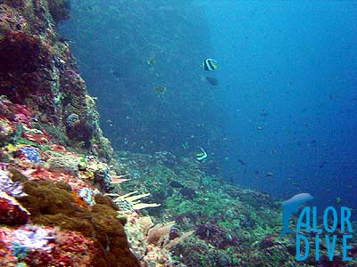
Alor and Lembata Islands are the least visited and are therefore the most unspoiled regions of East Nusa Tenggara (NTT). Trek to the rim of Pantar volcano, visit the traditional whaling village on Lembata or dive the straits of Alor at a dive destination rated by all to be amongst the best in the world.
Alor Island regency is the least visited and therefore the most unspoiled region of Nusa Tenggara Timur (NTT). Trek to the rim of a volcano on Pantar or dive the straits of Alor and Pantar in a dive destination rated by all to be amongst the best in the world. Ponder on the existence of the Moko drums, which are not found in large numbers anywhere else in Indonesia and can be traced back to the Dongson period in Vietnam around 350 BC and you start to realize that Alor is truly a land lost in time.
Alor diving is known as the best in the world With its smoldering Volcanoes reaching down into crystal clear waters fringed with pristine coral reefs, coconut fringed pure white sandy beaches and traditional villages built half way up mountains, the scenery is as spectacular above as it is below the waterline. Alor Island is so mountainous that it is almost impossible to pass from one side to the other and many of the villages on the island itself can only transport themselves via small wooden ferries. The eight distinct dialects and more than 50 sub-dialects spoken today, testifies to the diversity on Alor.
Alor traditional culture has been influenced over the ages by the Indian, Chinese and Javanese traders as well as by the Islamic and Christian religions. This can be seen in the silk thread woven into the original weavings and the mix of Mosques and Christian churches dotted throughout the Island. The traditional dances, Ikat weavings motifs and the varies architectural style greatly from area to area. With more than a dozen traditional villages within one hours drive from the capital Kalabahi - Alor is a cultural tourists heaven.
Lembata Island is known throughout the world as the home of traditional whaling but what is not known is that the people of this Island are especially rich in cultural tradition. The beautiful rich Ikat weavings are entirely made from homegrown cotton, spun and dyed by the weaver. These cloths are still important as they are exchanged during marriage for Ivory tusks between the two families. The scenery throughout the Island is breathtaking, from the ever-imposing "Ile Ape" volcano of the palm fringed bays to the colorful bustling local markets - beauty and excitement are everywhere.
Lamalera village located on the southern tip of Lembata Island is the home of a traditional whale hunting community. Here, Sperm Whales have been hunted for centuries using all hand made equipment; their spears, rope and boats are all made in the village. The boats are without motors and the harpooner must jump from the boat to implant his harpoon in to the whale to ensure success. All parts of the whale are either consumed or traded with other Islanders for corn or other food. While whale hunting is not generally condoned by modern societies, when consider the ancestral links, the primitive equipment used and the importance to the people of Lamalera it is understandable that this traditional hunting has been sanctioned by the United Nations.
![]()

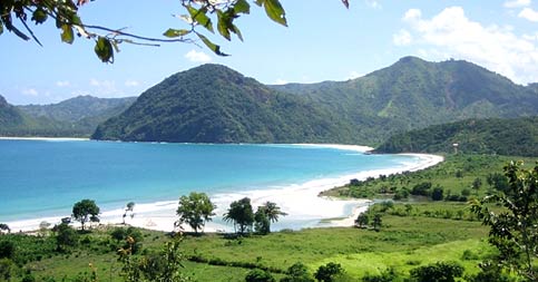
Rote Island is a part of Kupang Regency and is the southernmost island of Indonesia. It is located in the west coast of Kupang. This exotic island can be reached only in four hours. From Kupang by inter-island ferry to dive and tour this untouched beautifully rugged land. Spectacular walls and caverns mirror the hills, valleys, and escarpments underwater. The marine life is so varied and profuse that is hard to believe from Fire-fish to Mantas. The architecture of Rote is unique, as is their exquisite ikat weaving. See the people is their traditional lifestyle, which has remained unchanged for centuries.
Rote has many historical relies including fine antique Chinese porcelains, as well as ancient arts and traditions. Many prominent Indonesia nationalist leaders were born here. A popular music instrument Sasando, which is made of palm leaves. According to legend, this island got its name accidentally when a lost Portuguese sailor arrived and asked a farmer where he was. The surprised farmer, who could not speaking Portuguese, introduced himself, "Rote".
Rote just off the southern tip of Timor Island consists of rolling hills, terraced plantations, and acacia palm, savanna and some forests.
The rotinese depend, like the Savunese, on lontar palm for basic survival, but also as the supplement their income with fishing and jewelry making.
Rote just off the southern tip of Timor Island consists of rolling hills, terraced plantations, and acacia palm, savanna and some forests.
The rotinese depend, like the Savunese, on lontar palm for basic survival, but also as the supplement their income with fishing and jewelry making.
Before Indonesia's Independence, Rote, boasted the highest density of kingdom in the East Indies. Even today the island, the Rotenese and their kingdoms are divided, following ancient tradition, into two domains, one known as Sunrise and one as Sunset. A “male” Lord, a “female” Lord and several advisers, representing the clans within that domain, rules the domain. Each clan that possesses ceremonial rights performs it's own rituals during the annual HUS celebration, a traditional New Year festival. At the HUS, Rotenese men wearing their unique hats make offerings to the clan ancestors and the women dance accompanied by sasando, The Rotenese guitar.
Rote is particularly well know for its surfing, each year surfers flock to Namberala to ride the near perfect tubes formed by the shallow reefs and off-shore winds. Accommodation in Namberala includes a traditional beachfront bungalow resort and several home stays. The beach itself is one of the best examples of a palm fringed pure white sandy beach to be found anywhere. Diving in the area is also exceptional due to the large numbers of Manta and Dugong seen there. A boat trip to nearby Dana or Ndao Islands is also recommended.
![]()

Sumba, formerly known as the Sandalwood Island, is known foe its horses and Sumba clothe. Sandalwood was the only known cure for many diseases until penicillin was invented. The Sumbanese traded with the Chinese until the 16th century, after which the Arabs became the most important trading partner until the early 20th century. The island is famous for its arts and handicrafts, particularly the textile "ikat" weaving. Sumba, however, is not for everyone. Neither the food nor accommodations are up to international standards. But if we are willing to make a little effort we can see an authentic, ancient culture with none of the layers of Hinduism or Islam mostly found elsewhere in the country.
The island has a small population and a dry tropical climate. In total Sumba have more hours of sunshine than any other place in Indonesia. The land resembles Southern Africa or Australia, with scattered small villages and herds of cattle and buffalo Sumba is off the beaten track. Transport system and roads are infrequently used. Most hotels in main towns are simple, only catering for the adventurous. However, CNN etc. are available for those wishing to stay in touch with the outside world. Beaches are long and clean. Water is clear and abundant in fish, and there is great surf.
+Pasola+Festival-Sumba+Island.jpg)
The island is roughly oval in shape. The greatest concentration of those who worship sprits (ancestral and those of the land) is found in West Sumba where two-thirds of the population holds on their traditional belief. It is here where incredible rituals take place, the "pasola" where hundreds of horsemen fling spears at each other. The government allows the ritual to take place, but the spears must be blunt. Although some exist in East Sumba, it is in West Sumba that one can find a greater number of huge megalithic tombs and traditional thatched and peaked huts raise on stilts.
Many traditional activities, all with a part paying homage to the spirits, take place in the month of July through October. These include the building of "adapt" houses and burials when sometimes hundreds of pigs, water buffaloes, horses, and dogs are sacrificed. Other ceremonies include the "pajura" or traditional boxing, the festivals for lunar New Year in October and November, and August 17, Independence Day, horse races and ritual dances.
![]()

Flores, a long island located between Sumbawa and Timor, is strewn with volcanoes in a mountain chain dividing it into several regions with distinctive languages and traditions, scenic beauty, good beaches, and natural wonders. The name is Portuguese for "flower", as the Portuguese were the first Europeans to colonize East Nusa Tenggara.
Occupying a unique position at the junction of the Australian and Asian submarine ridges, between the two distinct fauna regions marked by the Wallace Line, here is one of the world's most dynamic marine environments with nearly every species of coral and tropical fish represented. Predominantly Catholic, there are several examples of its Portuguese cultural heritage like the Easter Procession held in Larantuka, and the royal regalia of the former king in Maumere.
Flores Island, 6,627 sq mi (17,164 sq km), of Indonesia, is one of the Lesser Sunda Islands. Flores is heavily wooded, rugged, and mountainous, rising to 7,872 ft (2,399 m). The inhabitants are predominantly Christian, mainly Roman Catholic; those in the west are chiefly Malayans, and those in the east are Papuans. Corn and coconuts are grown. Ende (1990 pop. 48,966) is the chief town and port.
Among the prehistoric inhabitants of the island were small-proportioned humans (classified as Homo floresiensis in 2004) that may have evolved from Homo erectus and lived on Flores as recently as 13,000 years ago. Some scientists, however, believe that remains are those of micro cephalic modern humans who also suffered from dwarfism. Much later under the rule of Sulawesi princes, Flores came under Dutch influence c.1618. The Dutch gradually gained control of the island, although Portugal held the eastern end until 1851 and the natives were not completely subjugated until 1907.
Flores is one of the Lesser Sunda Islands, an Island arc with an estimated area of 14,300-km_ extending east from Java island of Indonesia. The largest town is Maumere. Flores is located east of Sumbawa and Komodo and west of Lembata and Alor archipelago. To the southeast is Timor. To the south, across the Sumba strait, is Sumba and to the north, beyond Flores Sea, is Sulawesi.
Administration
Flores is part of the East Nusa Tenggara province. The island is split into five regencies (local government districts); from west to east these are: Manggarai, Ngada, Ende, Sikka and Flores Timur.
Flores is part of the East Nusa Tenggara province. The island is split into five regencies (local government districts); from west to east these are: Manggarai, Ngada, Ende, Sikka and Flores Timur.
Geography
Flores has several active and dormant volcanoes, including Egon, Ilimuda, Leroboleng, and Lewotobi.
Flores has several active and dormant volcanoes, including Egon, Ilimuda, Leroboleng, and Lewotobi.
Flora and fauna
The west coast of Flores is one of the few places, aside from the island of Komodo itself, where the Komodo dragon can be found in the wild. The Flores giant rat is also endemic to the Island. In September 2004, at Liang Bua Cave in western Flores, Paleoanthropologist discovered skeletons of a previously unknown hominid species. Homo floresiensis, affectionately termed hobbits after the small characters in the Lord of the Rings, appear to be miniaturized versions of Homo erectus standing about one meter tall. They may have existed until as recently as 11.000 BC. Local reports of elf people, the Ebu Gogo, or the Orang Pendek of Sumatra, have caused speculation that Flores man may have survived into the historical period, or even to the present. The discovery has been published in the October 28, 2004, issue of Nature magazine. Flores was also a habitat of the extinct Stegodon dwarf elephant until approximately 18,000 years ago.
The west coast of Flores is one of the few places, aside from the island of Komodo itself, where the Komodo dragon can be found in the wild. The Flores giant rat is also endemic to the Island. In September 2004, at Liang Bua Cave in western Flores, Paleoanthropologist discovered skeletons of a previously unknown hominid species. Homo floresiensis, affectionately termed hobbits after the small characters in the Lord of the Rings, appear to be miniaturized versions of Homo erectus standing about one meter tall. They may have existed until as recently as 11.000 BC. Local reports of elf people, the Ebu Gogo, or the Orang Pendek of Sumatra, have caused speculation that Flores man may have survived into the historical period, or even to the present. The discovery has been published in the October 28, 2004, issue of Nature magazine. Flores was also a habitat of the extinct Stegodon dwarf elephant until approximately 18,000 years ago.
Cultural
There are many languages spoken on the island of Flores, all of them belonging to the Austronesian family. In the centre of the island in the districts of Ngada and Ende there is what is variously called the Central Flores Dialect Chain or the Central Flores Linkage. Within this area there are slight lingistic differences in almost every village. At least six separate languages are identifiable. These are from west to east: Ngada, Nage, Keo, Ende, Lio and Palu'e, which is spoken on the island with the same name of the north coast of Flores. Locals would probably also add So'a and Bajawa to this list, which anthropologists have labeled dialects of Ngadha.
Portuguese traders and missionaries came to Flores in the 16th century, mainly to Larantuka and Sikka. Their influence is still discernible in Sikka's language and culture.
Flores is almost all Catholic and represents one of the "religious borders" created by the Catholic expansion in the Pacific and the spread of Islam from the west across Indonesia. In other places in Indonesia, such as in Maluku and Sulawesi, the divide is more rigid and has been the source of bloody sectarian clashes.
![]()

Indonesia Tourism describes:
Larantuka is a neat clean seaport with a beautiful view. Everything is within walking distance except for the pier where the boats leave for Timor (4-5 km from town). [...Larantuka is a] little port nestled at the base of a tall hill at the eastern end of Flores, from where Solor, Adonara, and Lembata islands (the small islands near by) are visible across the narrow strait. [...] people are very outgoing and friendly. Their bemos are brightly painted with murals on the sides and their radios are blasting the latest tunes. Lots of Catholic churches line the roads with a few mosques sprinkled in. [...] There are a number of tuna boats at the docks. They have a big square platform on the bow where fishermen line up with bamboo poles line up flipping hooked tunas
Another (perhaps less biased) source confirms the affability of the locals:
The town of Larantuka is a quaint little place with the friendliest people we met all the way across Indonesia. On landing on the beach we were mobbed by a group of kids shouting "Hello Mister!" the standard Indonesian English greeting. When they saw I had a camera, they started to ask me to take their picture. Opening up the camera caused all sorts of pandemonium and the parents suddenly showed up wanting to get in the picture as well. [...] When he rewound the tape and played it back the crowd watching themselves on the small screen couldn't stand up they were laughing so hard. We left our new friends of the beach and set out in search of [my friend who we found...] sitting in the middle of about 50 children. Every time he would ask one of them what their name was, riotous laughter would break out in the whole group.

Larantuka is a neat clean seaport with a beautiful view. Everything is within walking distance except for the pier where the boats leave for Timor (4-5 km from town). Even that is a pleasant walk if we do it early enough before it gets too hot. A little port nestled at the base of a tall hill at the eastern end of Flores, from where Solor, Adonara, and Lembata islands (the small islands near by) are visible across the narrow strait. An Old Portuguese cultural heritage like the Easter Procession is held in this town, and worth seeing. Flores people are very outgoing and friendly. Their bemos are brightly painted with murals on the sides and their radios are blasting the latest tunes. Lots of Catholic churches line the roads with a few mosques sprinkled in. Larantuka is a pleasant little town on the Far East end of Flores. There is a harbor in town and another one a few kilometers away where the ferryboat leaves to Kupang and Rote in West Timor. The boats going to Alor leave from the one in town. There are a number of tuna boats at the docks. They have a big square platform on the bow where fishermen line up with bamboo poles line up flipping hooked tunas.
There are 6 to 8 water jets that spray a steady stream of water on the surface to attract the tunas and then baitfish are tossed in driving the tunas into a feeding frenzy. These are not the big yellow or bluefin tunas but the smaller ones about 2 feet in length. They are often seen for sale by roadside vendors along the road from Maumere. There are some New Orleans style cemetaries along the beach on the way. They are well maintained and very colorful. These people put a lot of work into them.
![]()
![]()

The Concepts of the Rinjani Trek Management Board
The Rinjani Trek is managed by a unique partnership of National Park, tourism industry and the local community. Activities focus in the Community – run cooperatives at Rinjani Trek Centre ( RTC ) in Senaru and the Rinjani Information Centre ( RIC ) in Sembalun Lawang. Under the guidance of the Rinjani Trek Management Board ( RTMB ), each are run by a stakeholders’ committee who look after roster systems for guides and porters, village tours, trek trail maintenance, and handicraft sales. Revenue from tourism activities and entry fees is used for conservation, training and management of the Rinjani Trek, thus ensuring sustainability.
The Rinjani Trek is managed by a unique partnership of National Park, tourism industry and the local community. Activities focus in the Community – run cooperatives at Rinjani Trek Centre ( RTC ) in Senaru and the Rinjani Information Centre ( RIC ) in Sembalun Lawang. Under the guidance of the Rinjani Trek Management Board ( RTMB ), each are run by a stakeholders’ committee who look after roster systems for guides and porters, village tours, trek trail maintenance, and handicraft sales. Revenue from tourism activities and entry fees is used for conservation, training and management of the Rinjani Trek, thus ensuring sustainability.
 Conceptually, the project started with three stakeholder circles labeled “Park Management”, “Community Development” and “Tourism”. Whit Project assistance, the Park set out to engage with the stakeholder groups in each of the circles, independently at first and then, as the groups got used to deal with each other, increasingly together. This approach recognized that it takes time for the multi-skilled “cross-over” people that ecotourism requires (people who can operate in between the circles) to emerge.
Sasak Hill Trek
A two days-one night, great experience over Pegasingan Hill We invite you to join our two–day walk through the rice fields, to chat with the farmers and enjoy the scenery from the…
Program Details
A two days-one night, great experience over Pegasingan Hill We invite you to join our two–day walk through the rice fields, to chat with the farmers and enjoy the scenery from the…
Program Details
Best time to trek in Rinjani : April to November
Designated : Minister of Forestry, SK.No.280/Kpts-II/97,
a total area of 41,330 hectares
Location : Regencies; West Lombok, Central Lombok and
East Lombok, Province of West Nusa Tenggara
a total area of 41,330 hectares
Location : Regencies; West Lombok, Central Lombok and
East Lombok, Province of West Nusa Tenggara
Temperature 23° – 30° C
Rainfall 2,000 mm/year (on average)
Altitude 550 – 3,726 m asl.
Geographical location 116°18′ – 116°32′ E; 8°18′ – 8°33′ S
Rainfall 2,000 mm/year (on average)
Altitude 550 – 3,726 m asl.
Geographical location 116°18′ – 116°32′ E; 8°18′ – 8°33′ S
Advisory Warning For Tourists
Recently tourists have purchased trekking packages from a false office in Padang Bai, Bali claiming to represent the Rinjani Trek Management Board (RTMB). Please note that RTMB has only one main office located at the Lombok Raya Hotel in Mataram with representative offices at the Rinjani Trek Center in Senaru and Rinjani Information Center in Sembalun, all located on the island of Lombok. Any other locations claiming to represent RTMB are fraudulent and should be avoided. If you have any questions, Contact Us to submit an enquiry.
Recently tourists have purchased trekking packages from a false office in Padang Bai, Bali claiming to represent the Rinjani Trek Management Board (RTMB). Please note that RTMB has only one main office located at the Lombok Raya Hotel in Mataram with representative offices at the Rinjani Trek Center in Senaru and Rinjani Information Center in Sembalun, all located on the island of Lombok. Any other locations claiming to represent RTMB are fraudulent and should be avoided. If you have any questions, Contact Us to submit an enquiry.
Benang Stokel and Benang Kelambu Waterfalls Panorama Trekking

BENANG STOKEL WATERFALL
Benang Stokel,-Meaning Literally, a Ball of thread, located in Aik Berik Village, Batukliang Utara Sub-district, 22 km north of Praya. Fresh and cool water falls from 20 meter high trough the steep rock face, covered by the variety of vegetations; the moss, forming lush green wall till the raft where lies small valley for bathing. The falling water seems to ply down joyfully, sliding one after another, cussing down and sounded as if boiling water. Local people believe the water has curative qualities. Facilities serve such food stalls, coffee stalls and realtor. This place is crowded by local people, especially Sunday or holidays.
By the increase number of adventure interest, a trekking route into Segara Anak Lake has recently opened in this area, as well security post.

BENANG KELAMBU WATERFALL
As if the curtains hanging over the air, blown by fresh wind, forming the beautiful space of scenery, is Benang Kelambu Waterfall. It is located only 1 Km from Benang Stokel, could be reached by car then visitors trail through the dense forest inhabited by long-tailed monkeys. This bathing site has natural cold water that flows over the slits of the stones in 35 high. Visitors favor this place for bathing while enjoying the beautiful panorama especially in Sunday and holidays.

Bored with big city atmosphere, visit the vivid green nature and pure culture on this tour. Drive to Central Lombok to find and enjoy the fresh air of rainforests and views of terraces with community farming activities.
Benang Kelambu waterfall Lombok located about 30 minutes walking from Benang Stokel waterfall Lombok. It will take an extra energy because its rather like trekking trail, up and down trail and more adventurous. The trail surrounded by social forest mixed up with rain forest. It’s also new-opened trail, it’s new managed access to this benang kelambu waterfall. And the visitors are countable.The waterfall is special and very unique. The waterfall look likes a big net which is spread out, that’s way it’s called Benang Kelambu in local language Sasak. It’s about 40m of height and have two graded irregularly. The dense of herbs make it seem more naturally.

What to bring:
Make sure you bring your camera, sun hat and sun cream, comfortable walking shoes, small backpack and bottle water.
Source:http://rinjanimountain.com
![]()

Mayura Park is what remains of the once existing Karang Asem kingdom of Bali. In the middle of a large pond is a structure called Balai Kambang, which at the time functioned as a legal court of justice as well as a hall for important meetings. Curiously, its architecture shows both Hindu as well as Islamic influences, whereas around the place statues made of stone are found in a Moslem hajji form.
Mayura and Bale Kambang, had built on 1743 by Balinese Hindu's Dynasty; Anak Agung Gede Karangasem. It's now become a recreational park when seasonally used for Music Festivals.
Mayura and Bale Kambang, had built on 1743 by Balinese Hindu's Dynasty; Anak Agung Gede Karangasem. It's now become a recreational park when seasonally used for Music Festivals.
The Mayura Park is what remains of the once existing Karang Asam kingdom of Bali whose King A.A. Ngurah built it in 1744. In the middle of a large pond is a structure called “ Balai Kambang “ which at the time functioned as a legal court of justice as well as a hall for important meetings. Curiously, its architecture shows both Hindu as well as Islamic influence, whereas around the place statues made of stone are found in the form of a Moslem hajji. The palace was built in the centre of Cakranegara to serve Balinese court. The full moon of the fourth month of the Balinese calendar, is the date of Mayura's most important ceremony.

Balinese conquest of Lombok resulted in bringing strong Hindu influences on the lives of the indigenous people of Lombok. Temples were built dedicated to Hindu pantheons and some of them till this day are revered and visited. Lombok can be described as paradise in miniature, the calm sea, diverse flora and fauna and a tranquil way of life made this paradise favorite of Balinese kings too. They built palaces where much of fun, frolic and work was done, the ruins of such palaces still allow one to get a glimpse of royal life. Before Lombok was colonized by the Dutch the island was part of Karangasem Kingdom of Eastern Bali. It was the most powerful Balinese kingdom in the eighteenth century.
The kingdom’s last raja was very fond of water and has several fountains, moats and pools created. In Lombok, Taman Mayura Palace is one such remnant of the Balinese royal palace. Reaching it is only 1.5 hours from Villa Atas Ombak.
![]()
Kuta Beach Lombok attract visitors for its beautiful virgin beaches and surfing spots. Surfers from all over the world find Kuta Lombok as a surfer paradise.
South coast of Lombok is famous for the high waves and Kuta Lombok is a good base for the surfers. Many visitors come back year after year to surf the famous Kuta waves. Whether you are an experienced surfer or a beginner you will find the surf spot for you. Surf boards & boogie boards are available to rent or bring your own.
You will need transport to the waves from Kuta, most guests choose to rent motorcycles which come with a special surf rack attached. The new International Airport is now being developed and big plans to develop a whole stretch of the superb south coast with luxury hotels. After many years of speculation there are signs something is happening, with the road from Praya completely remade and big new road running to as yet undeveloped beaches. Meanwhile, Kuta and South Lombok is now getting famous and raise visitor's curiosity.
![]()

Narmada Park is located in the Village Lembuah, Narmada district, West Lombok regency, some 10 kilometers east of Mataram, West Nusa Tenggara. Park which covers about 2 hectares was built in 1727 by King of Mataram Lombok, Anak Agung Ngurah Karang Asem, as a place Pakelem ceremony held every full moon Caka fifth year (October-November). In addition to the ceremony, Narmada Park is also used as a resting place of the royal family during the dry season.
The name of Narmada is taken from Narmadanadi, the son of a very sacred Ganges River in India. For Hindus, the water is a sacred element that gives life to all beings in this world. Water emanating from the soil (spring) is associated with Tirta Amrita (immortality water) emanating from Kensi Sweta Kamandalu. Formerly the possibility of Narmada name used to name the name of springs that form several ponds and a river in that place. Eventually used to refer to the whole complex of temples and Narmada Park.

Narmana Park Complex
Narmana Park complex in Lombok it can be divided into several parts, the main gate, jabalkap, twin lake, gate bracelet / paduraksa, mukedes, padmawangi lake, lodge hall, bright hall, patandaan, sakapat buildings, halls bancingah, Pura hump and Pura Lingsar. The following will described the parts of the Narmada Park from the main gate.
Arch-shaped main gate and was briefly on the north. Once we enter the main gate jabalkap page, in which there is the twin lake. In the southern part jabalkap there is a gate called the Gate Bracelet or Paduraksa that links between pages jabalkap with mukedes page. On page mukedes there are several pieces of buildings, among others Sanggah Temple, Hall and Hall Pamerajan lodge (one of the buildings between the king's residence). In the southeast there is a gate mukedes page to the page pasarean. On this page there are also paseran Hall lodge, Lake Padmawangi, Pawedayan, pawargan, Light Hall, and a new building that does not clear the status. Light Hall is a building that serves as a resting place / king bed, shaped stage made entirely of wood. The top of the building which used to enjoy the open view of the Meru temple on the east side. Doors and windows Light Hall is patterned single month and herbs.
In the east there is a page pasarean hump or Pura Pura Narmada. Architecture resembles a staircase shape punden. The most sacred part contained in the central courtyard in the most above steps (temple in Bali's most sacred pages is generally the most rear). This temple temple belonging to the universe or a temple common to all Hindu Dharma and is one of eight old temple on the island of Lombok. Narmada temple situated on a cliff-steps staircase, being under the cliffs of the valley and the lake there are mermaids swimming child soon.
South there pasarean page patandaan page. On this page there are two buildings patandaan sakapat wantilan which is a kind or four-poster outdoor stage. On this page often held a variety of performances. While in the south there Patandaan bancingah page. Left on this page is now just a wall around the yard with two gates for a while.
Elements of other buildings that actually there are many, including showers nine (Siwak) is located on the Segara Anak. The shape of the building with two separate sections dorogancet resemble traditional building in Central Java. This building includes a building sacred to both Hindus and followers of Dharma Tilu Time.
In addition, there are also a source of Hall petirtaan its water comes from Mount Rinjani. Petirtaan Hall is also the meeting place of three sources of water, namely Suranadi, Lingsar, and Narmada. For the eyes of its water comes from Mount Rinjai and meeting place of three other springs, the water that exist in Central petirtaan can be trusted to make the people who drank and washed her face with water in it will stay young.
Other buildings in the Narmada Park complex in the form of landscaping has been difficult to trace its authenticity. According to the map of 1899 parks in the Narmada Park complex are: Angel Park, Garden Anyar Paresak Parks, and Parks hump. Newer parks and park hump is now a township resident. While the park has now become Paresak orchards with the main crop is the mangosteen fruit. (Ali Gufron)
![]()

Who do not know Senggigi Beach. Senggigi beach very famous in Indonesia, more than anything else in Lombok island, location of Senggigi Beach reside in. Lombok Island reside in archipelago of Nusa Tenggara, And represent the part of West Nusa Tenggara province. Lombok Island nearby as Bali Island. If in Bali Island there are Kuta Beach, Sanur Beach, Legian Beach, Dreamland Beach, etc. hence in Lombok Island there are balmy Senggigi beach. By of beauty, senggigi beach do not fail to respect with Kuta Beach.
Many people think Bali have too solid and crowded so that make Lombok island become a very good alternative, because its natural beauty not fail by Bali. More than anything else both very nearby. Lombok island offer resorts which very capture. Available also hotels at the price of varying, from costly until economic valuable hotel. Lombok island have separate fascination for tourist. Many tourist pass the time to enjoying sunset in Senggigi beach.
Besides beautiful beach, Senggigi also have the amaze under sea. Senggigi under sea is very beautiful, and tourist can do snorkling as satisfied as because its wave do not big. In Senggigi Beach you also can try to shar water sport. Don’t far from Senggigi Beach, there are Batu Bolong Gate, About 3 km from Senggigi Beach. This gate is a woke up gate above rock which located in coastal edge. From this place also seen Agung Mount in Bali Island. Don’t far from Senggigi Beach also there are artistic market, selling various unique goods as souvenir.

Senggigi Beach Lombok is the main tourist strip of the Indonesian island of Lombok, stretched out along the several kilometers of the beachfront, just to the north of the capital Mataram. The site of a building frenzy in the late 1990s when Lombok was hyped to be the next Bali, the communal violence of 2000 and the 2002 Bali bombing dealt Senggigi a severe blow, with tourist numbers declining precipitously and many construction projects halted.

Senggigi Beach Lombok is the most developed area for tourists on Lombok. You can find a variety of restaurants, bars, discotheques, travel agents, photo processors, money changers, souvenir shop and a range of accommodations starting from budget guest house to 5 star hotels. Restaurants and small cafes line the colorful main beach road. Swimming off the beach is safe.
![]()
![]()
Bung Karno's tomb is located in the Village Bendogerit, Sanan wetan Blitar City District, East Java. Bung Karno's tomb, accompanied on either side of the Tomb of Father "R. Soekeni Sosrodihardjo" and the Tomb of Mother "Ida Aju Njoman Rai".
Entering the tomb was started from a great gate facing south. The main building called the Dome Tomb of Bung Karno. Dome-shaped tomb Bung Karno Joglo building, the building art form of Java that has been known long ago.
Entering the tomb was started from a great gate facing south. The main building called the Dome Tomb of Bung Karno. Dome-shaped tomb Bung Karno Joglo building, the building art form of Java that has been known long ago.

Dome Tomb of Bung Karno is named Astono Mulyo. The tomb is placed above a black marble stone reads: Here is buried Bung Karno Proclaimer of Independence and First President of the Republic of Indonesia. Tongue connective Rakyat Indonesia.
Bung Karno Library is located in the south together with the Tomb complex on Jalan Bung Karno Kalasan no. 1 Blitar. Bung Karno Library is managed by the National Library through UPT Bung Karno Perpusta kaan (PPBK) in the City of Blitar.
Besides the library building, was filled with 2 PPBK artwork, the form of the Statue of Bung Karno, located in the middle of building a first floor, and wall reliefs contain Bung Karno journey that spans the pool from the library to the tomb.


Haul warning other than the commemoration of Bung Karno, Bung Karno dying day since July 21, 1970, also became a vehicle for teaching menteladani struggle and Bung Karno. The highlight of the celebration took place in the House of Gebang Palace Gebang or Ndalem Gebang an elderly residential home Bung Karno.
This palace is located on jl. Sultan Agung no. 69, Biltar. As the show haul Bung Karno from year to year than at the Palace Gebang event was also held at the Bung Karno tomb complex continuing sow flower show in the morning.


![]()
Sarangan lake is a tourism place that located on Magetan East Java. This lake also known as sand lake and it can be face in foot of Lawu Mountain.Sarangan Lake has 30 hectare in large and 28 meters in depth. There are many touris has come to this lake and enjoying all of objects and facilities that provided over there.
Sarangan lake is one of main tourism destination in Magetan and supported by many facilities which will make your vacation worth enough. Facilities that we can find there are hotels, Restaurants, Playing gardens and many others. With more that 19 restaurant there we can select various menus.
Some annual activities that interested enough like school holiday, Labuh sesaji, Ledug Sura and skyrocket party bcome some moment that interesting for most people to be visited and take part in crowded. We can do the other activity during spend our vacation there, like riding horse to go aroung sarangan lake, going aroung sarangan lake with ship if we we willing to pay Rp 20.000,00.
Then if you want to bring some thing for people in your home you can get many places that provide many kinds of souvenirs.
Magetan is one of regencies in East Java Island that bordered with Central Java province. Magetan regency region that located in Mount Lawu foot is rich of nature tourism such as lake, waterfall, etc. Magetan regency has a lot of nature tourism objects that spreads almost over its 13 districts. One of the most interesting tourism objects is Sarangan Lake. Beside that, there are also historical tourism objects such as; temple, grave and inscription.
Magetan regency also has industries of feather art, bamboo, and traditional music. It also developed the agriculture and horticulture that give it the vegetables and oranges. The famous orange of Magetan is pamelo and Srinyo orange. Those orange plantation is located in Sukomoro and Bendo district, Magetan.
Beside its tourism object and orange plantation, Magetan also famous with its traditional art such as; Gondang Baru dance, Iring-iring dance, and Godril dance.
Visit Magetan tourism in East Java - Indonesia and enjoy its wonderful natural tourism with various handmade souvenirs.
![]()

Coban Talun Waterfall tourism is located in Junggo sub-village, Tulungrejo village, Bumiaji district. The waterfall is lying between the big stones. The big rock of white stone have predominate the contents of river. In the waterfall base there is superficial pool water what overflows pool.
Coban Talun waterfall is surrounded by forest and cool mountain. Because of the natural beauty, this area often used as camping ground area. This camping ground is located in one area with Coban Talun waterfall. The natural and cold area, make many visitors, either from education world and public, interesting to visit this camping. But the visitors should have fit stamina to reach the location, because the path is sloping way.
Japan Cave Of Coban Talun
A Cave that has 5 meters depth is located in Coban Talun area, not far from its pool. It is located in Junggo sub-village, Tulungrejo village, Bumiaji district. This cave has unique structure; looks like letter ‘T’.
![]()

East Java (Jatim) Park is located in Jl. Kartika 2 Batu offers recreation tourism of new entertainment amusement for all level. It begins from children, finite adolescent until grandmother and grandfather. Of course, this tourism object has drawn up as family tour area in East Java. To get to the location, is not too difficult, because, the object only 2, 5 kilos meters from Batu city. This tourism object is about 22 hectares width with 850 meters height to sea level, save the multifarious knowledge, and recreation area with various supporting facilities for having relax.

Jatim Park may have said as the different tourism object in East Java province, besides offering a recreation place and study center, we will get many kind new knowledge. Jatim Park has at least 36 kinds of facilities which able to be enjoyed visitor. Before enjoy all supporting facilities for recreation area, the visitors will find an interesting view of ‘Galeri Nusantara’. Then stepped into ‘Taman Sejarah’, which contained of miniature temple in East Java like Sumberawan temple (Singosari- Malang regency), customhouse of Kiai Hasan Besari Ponorogo and Sumberawan Statue.
The other facility which able to be enjoyed is ‘Agro Park’ presenting crop and rareness fruits, animal diorama, which consists of unique animals that have been conserved, supporting games (bowling, throw ball, scooter disco), Ken Dedes and Ken Arok food centre, etc.
Jatim Park is suitable for family recreation. The recreation area sites here offer unforgettable tour and can used as alternative media of study for your children.
Jatim Park is suitable for family recreation. The recreation area sites here offer unforgettable tour and can used as alternative media of study for your children.

![]()

Mount Banyak is located in Songgokerto village, Batu district. Mount Banyak also has beautiful natural scenery. This mount is tourism object that being applied for unique sport called ‘Paralayang’ or ‘Gantole’ and down hill sport. Paralayang sport is free flying sport just like a bird. It is free natural sport. This sport is only done on hill and mountain. The athletes have to used wind to fly and enjoy the free air. The ordinary performed event or paralayang champion both international and national storey is often held in Mount Banyak.
Mount Banyak is facilitated with resting place and Paralayang bases. You will enjoy the beautiful nature scenery in Mount Banyak and also meet with some Paralayang athletes. If you interesting to try this sport, the guide will accompany you and feel the nature adventure here.

![]()

Batu town is placed in 800 measures above sea level, with cold 17-25,6 level of Celsius. Batu town is an place in Eastern Coffee that ornamented by mountains. Geographically, Batu is tropic place. The potencies of this place are coming from the agro product qualities, fruit, veggies, hill surroundings and the mountains. When the guests get into to Batu town, the clean hill air has accepted us.
Batu has explored its effort to show its tourism nature potency. The alternative that had done is warm pool Cangar, have corrected and renovated. Meanwhile, the other places as the alternative of new tourism also start to pop out, they are; Jatim Park, Selecta, Songgoriti, Agro tourism, Coban Rondo waterfall, Mount Panderman, Mount Arjuno, Mount Welirang, Mount Ukir, Mount Banyak.
Batu City is the main tourism object for domestic and foreign tourists. There are many tourism objects in Batu that become the dream object for those visitors, especially its mountain tour. To support those tourism objects, Batu has facilitated with hotels, inns, villas and the other lodges, which has mountain nuance. Beside that, Batu city also called as “Batu City A Millions Beauty”.
Batu City is the main tourism object for domestic and foreign tourists. There are many tourism objects in Batu that become the dream object for those visitors, especially its mountain tour. To support those tourism objects, Batu has facilitated with hotels, inns, villas and the other lodges, which has mountain nuance. Beside that, Batu city also called as “Batu City A Millions Beauty”.

Beside as tourism city, Batu City has many kinds of art culture, both art and tradisional culture, such as; Kuda Lumping (Horse Dance), Campursari (Javanese Music), etc. Batu is also known as agro city area and artist city, because it has many art and painting galleries.
Batu city also produces apples, vegetables, and garlic.
Batu city also produces apples, vegetables, and garlic.
![]()
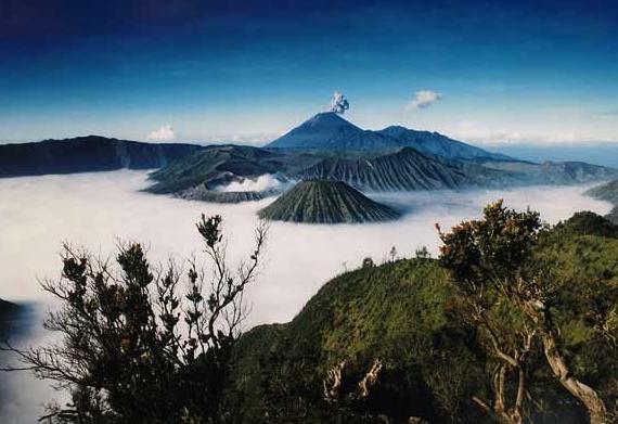
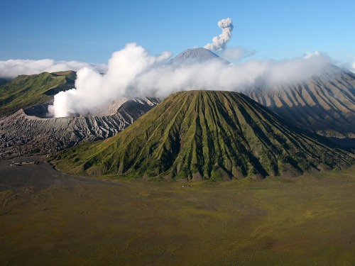
Bromo have known by all of guest of the sides. They come to Bromo to look at the dawn. The guest also can look down to the crater that complete of its smoking, and experience the freezing of the air, is probably could only be done in Bromo. Our eyes will also completed by the sea of sand that the way to reach Bromo's peak. The main gate to the sea of sand and mount Bromo is through Cemorolawang. This is the most crowded visiting area, espesially on holidays. There are many kinds activities that could be carried on this area such as; Camping, watching the scenery, horse riding to sea of sand or walking.
To get to the peak Bromo with its largely open crater, which belch of smoke expelling from its bottom. Mount Bromo has settled by Tenggerese for about thousands years. They who are good of God follower and always do their custom strickly, has historical relationship with Majapahit. The Antropologist from our country or other country are interesting to do some research, because the Tenggerese are strickly in keeping custom for centuries, without influenced by world's change. So there so many version of the unique of Tenggerese in Probolinggo, it can be in the forth of tale, folktale, serat and kidung, legend and science report.
To get to the peak Bromo with its largely open crater, which belch of smoke expelling from its bottom. Mount Bromo has settled by Tenggerese for about thousands years. They who are good of God follower and always do their custom strickly, has historical relationship with Majapahit. The Antropologist from our country or other country are interesting to do some research, because the Tenggerese are strickly in keeping custom for centuries, without influenced by world's change. So there so many version of the unique of Tenggerese in Probolinggo, it can be in the forth of tale, folktale, serat and kidung, legend and science report.

Some of the endangered and protected animal species inhabiting the Park are the marbled cat (Pardofelis marmorata), deer (Cervus timorensis russa), long-tailed macaque (Macaca fascicularis), barking deer (Muntiacus muntjak muntjak), red junglefowl (Gallus gallus), panther (Panthera pardus), Asian wild dog (Cuon alpinus javanicus) and various species of bird such as the besra sparrow hawk (Accipiter virgatus virgatus), crested serpent eagle (Spilornis cheela bido), rhinoceros hornbill (Buceros rhinoceros silvestris), black drongo (Dicrurus macrocercus), brahminy kite (Haliastur indus), and ducks that live on the Ranu Pani, Ranu Regulo and Ranu Kombolo Lakes.
Bromo Tengger Semeru National Park is the only conservation area in Indonesia that has a sand 'sea'. This unique feature covers a total area of 5,250 hectares at an altitude of about 2,100 m asl.
Beneath the sand sea, seven eruption centres have been found along two intersecting lines, one from east to west and the other from northeast to southwest. From this northeast-southwest line emerged Mt. Bromo, an active volcano which intermittently emits smoke and ash, and is an ever-present threat to the lives of some 3,500 people living below.
The crater of Mt. Bromo has a diameter of about 800 metres from north to south and 600 metres from east to west. Most of the area within a radius of 4 km from the crater centre is considered hazardous.

Semeru mountain
The Tenggerese people that live around the Park are indigenous to the area and adhere to ancient Hindu beliefs. According to legend, the ancestors of the tribe were members of the Majapahit kingdom who went into exile. Strangely, despite being aware of the potential dangers of Mt. Bromo, the local people seem unafraid. The same goes for the visitors who come to the Park in great numbers, particularly around the time of the "Upacara Kasodo". The Upacara Kasodo (Kasodo Ceremony) is held every year (December/January) at the full moon. Through this ceremony, the Tenggerese invoke the blessings of the deities to ensure an abundant harvest, to be spared from calamity and to be cured of various diseases. To earn such blessings, they climb down the sides of the crater to catch the offerings thrown into the crater by other members of the community above. The scramble for possession of the 'sacrifices' is at once a gripping, but terrifying sight: it is not uncommon for some of the participants to tumble down to the crater's floor.
![]()
![]()
Suroloyo summit, Kulon Progo District, Yogyakarta. The highest hill in Menoreh mountain , lies about 3500 feet above sea level. According to old story , Suroloyo summit known as meditation place of Raden Mas Rangsang whom is later known in his royal title as Sultan Agung Hanyokrokusumo. His meditation is a requisition to become fair and wise ruler.
in areas with an altitude of about 1,100 meters above sea level, one can witness such a beautiful landscape. If the weather clears, usually in the morning, one can see four big mountains in Java that is Merapi, Merbabu, Cleft, and Sindoro.

![]()
Subscribe to:
Posts (Atom)